Tilting photography technology is a high-tech developed in the field of international mapping and remote sensing in recent years. By carrying multiple sensors on the same flight platform, it simultaneously acquires images from different angles such as vertical and tilt to obtain more complete and accurate information of ground objects. The image acquired by the vertical ground angle is called a positive film, and the image taken by the lens at a certain angle to the ground is called a diagonal.
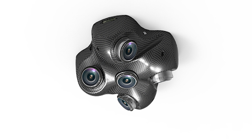
↑Motoar Sky MS-Q5 tilt photography system↑
What are the workflows for tilt photography modeling?
â—† Tilt image acquisition Tilt photography technology is not only different from traditional vertical aerial photography in terms of photography, but its post-data processing and results are also very different. The main purpose of the tilt photography technology is to obtain information on multiple orientations (especially the side) of the feature and to provide users with multi-angle browsing, real-time measurement, three-dimensional browsing and the like to obtain various information. The tilt photography system constitutes a tilt photography system divided into three parts:
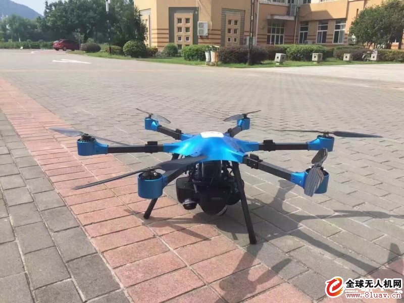
The first part is the flight platform, small aircraft or drone ;
The second part is personnel, crew members and professional aviation personnel or ground command personnel (unmanned aerial vehicles);
The third part is the instrument part, the sensor (multi-head camera, GPS positioning device to obtain the three line elements of the exposure instant x, y, z) and the attitude positioning system (recording the attitude of the camera exposure moment, three corner elements φ, ω, κ ).
Tilting photography route design and how the camera works
The route design of tilt photography is designed with dedicated route design software, and its relative altitude, ground resolution and physical pixel size satisfy the triangular proportional relationship. The route design generally adopts 30% side overlap and 66% heading overlap. At present, an automation model is required, the side overlap needs to reach 66%, and the heading overlap needs to reach 66%. The route design software generates a flight plan file that contains the route coordinates of the aircraft and the location coordinates of the exposure points of each camera. In actual flight, each camera automatically performs exposure shooting according to the corresponding exposure point coordinates.
â—† Tilt image processing
After the data acquisition is completed, the quality of the acquired image is first checked, and the unqualified area is filled up until the acquired image quality meets the requirements;
Secondly, the homogenizing and coloring process is carried out, and there is a difference in time and space during the flight, and there is a color shift between the images, which requires uniform coloring processing;
Geometric correction, point matching, and regional network joint adjustment are performed again. Finally, the adjusted data (three coordinate information and three direction angle information) is given to each oblique image so that they have a position in the virtual three-dimensional space. And the attitude data, so that the tilt image can be measured in real time, and each pixel on each oblique slice corresponds to the real geographical coordinate position.
The product specifications for tilted images are as follows:
Tilt images have the following characteristics:
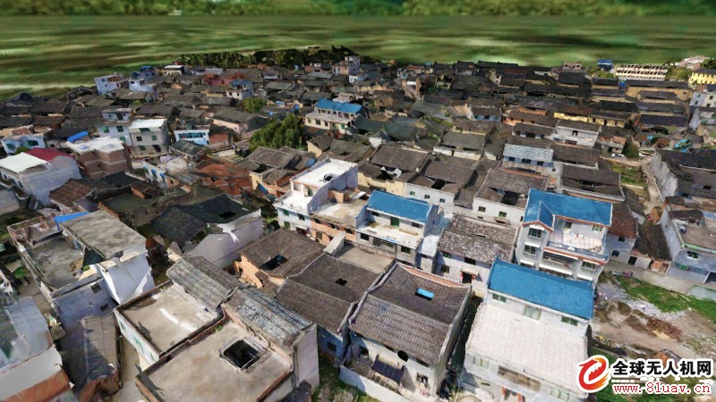
Reflecting the real situation around the object relative to the orthophoto, the tilt image allows the user to observe the object from multiple angles, more realistically reflecting the actual situation of the object, greatly making up for the lack of orthophoto based application.
Tilt image for single image measurement
Through the application of the supporting software, the measurement including height, length, area, angle, slope, etc. can be directly based on the result image, and the application of the tilt photography technology in the industry is expanded.
The side texture of the building can be collected for various 3D digital urban applications. The large-scale mapping of aerial photography, combined with the method of batch extraction and texture from oblique images, can effectively reduce the cost of urban 3D modeling.
The data format that is easy to publish oblique images on the web can be quickly published on the network with mature technology to realize shared applications.
For these characteristics, tilt photogrammetry technology usually includes image preprocessing, regional network joint adjustment, multi-view image matching, DSM generation, true shot correction, 3D modeling and other key content. The basic principle is shown in the figure: 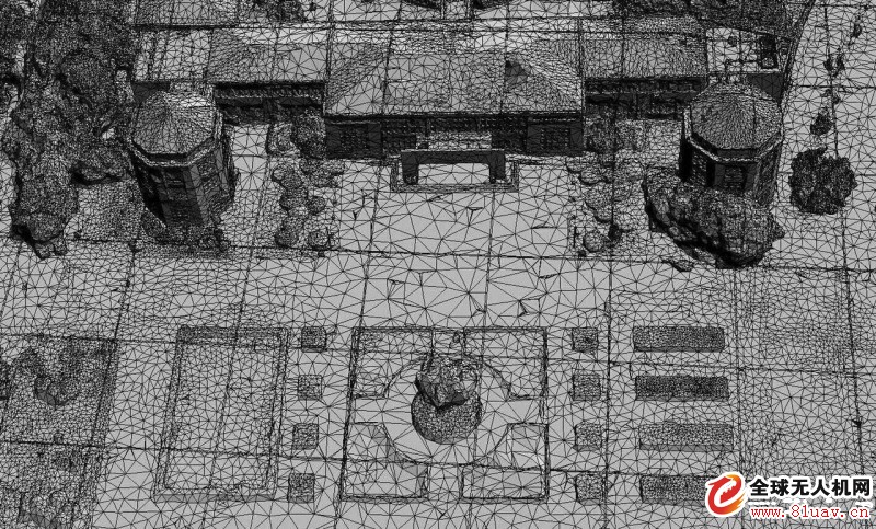
Key technologies for oblique photographic data processing:
Multi-view image joint adjustment
Multi-view images include not only vertical photographic data, but also oblique photographic data, and some traditional aerial triangulation systems cannot handle oblique photographic data well. Therefore, multi-view image joint adjustment needs to fully consider geometric distortion and occlusion relationship between images. . Combined with the multi-view image orientation element provided by the POS system, the coarse-to-fine pyramid matching strategy is used to perform the matching of the same-name point and the free-net beam method on each level of the image, and the better matching result of the same name is obtained. At the same time, the error equations of the multi-view image self-checking area network adjustment of the connection point and the connection line, the control point coordinates and the GPS/IMU auxiliary data are established, and the accuracy of the adjustment result is ensured by the joint solution.
Multi-view image intensive matching
Image matching is one of the basic problems of photogrammetry. Multi-view images have the characteristics of large coverage and high resolution. Therefore, how to fully consider the redundant information in the matching process, quickly and accurately obtain the coordinates of the same name on the multi-view image, and then obtain the three-dimensional information of the ground object is the key to multi-view image matching.
Since it is often difficult to obtain the same-named point required for modeling by using a matching primitive or matching strategy alone, multi-primary and multi-view image matching developed with computer vision has gradually become the focus of research in recent years. Much progress has been made in research in this area, such as automatic identification and extraction of buildings on the side. By searching for features on multi-view images such as building edges, wall edges and textures to determine the two-dimensional features of the two-dimensional vector dataset image of the building, the two-dimensional features of the different perspectives can be transformed into three-dimensional features, which can be set when determining the wall surface. A number of impact factors and given a certain weight, the wall is divided into different categories, the wall of the building is scanned and segmented in a plane, the side structure of the building is obtained, and then the building is reconstructed to extract the building. The height and contour of the roof.
Digital surface model production
Multi-view image intensive matching can obtain high-precision and high-resolution digital surface model (DSM), which fully expresses the terrain features and has become an important part of the new generation of spatial data infrastructure. Due to the large difference in scale between multi-angle tilt images, coupled with more serious occlusion and shadow problems, DSM automatic acquisition based on tilted images has new difficulties.
Firstly, according to the external image orientation elements calculated by the automatic space three solution, the image matching unit and the pixel-level dense matching are analyzed and selected, and a parallel algorithm is introduced to improve the calculation efficiency. After obtaining high-density DSM data, filtering processing is performed, and different matching units are fused to form a unified DSM.
Real shot image correction
Multi-view images truly correct digital object elevation models (DEMs) involving objects and a large number of discrete objects with widely varying granularities, as well as massive image-based multi-angle images with typical data intensive and computationally intensive features. Therefore, the true shot correction of the multi-view image can be divided into the object side and the image side simultaneously. Based on the DSM, based on the continuous terrain of the object and the geometric features of the discrete objects, the semantic information of the object is extracted by contour extraction, patch fitting, roof reconstruction, etc., and the image segmentation and edge are adopted on the multi-view image. Extraction, texture clustering and other methods to obtain the image semantic information, and then based on the results of joint adjustment and dense matching to establish the correspondence between the object and the image of the same name, and then establish a global optimization sampling strategy and joint correction to take into account the geometric radiation characteristics, At the same time, the overall homogenization process is performed to achieve true shot correction of multi-view images.
â—† Tilt model production
The oblique image obtained by oblique photography is processed by image processing, and the oblique photography model can be produced by special mapping software. The model has two kinds of achievement data: one is a single objectized model, and the other is non-singularized model data.
The singular model results data, using the rich visual details of the oblique image, combined with the existing 3D wireframe model (or other white model produced), through the texture mapping, the production of 3D models, the model produced by this process Data is an object-oriented model. Individual buildings can be deleted, modified and replaced. The texture can also be modified, especially the information that changes frequently in the building. This model can reflect its advantages. Representative companies such as the Motoar-sky QS tilt system form their own unique process.
The non-single model result data, hereinafter referred to as the tilt model, is a fully automated production method. The model has a short production cycle and low cost. After obtaining the oblique image, it is smoothed by homogenizing and other steps. The mold software produces a three-dimensional model. This process generally passes through the geometric correction of the multi-view image, joint adjustment and other processing processes, and generates a high-resolution oblique photography three-dimensional model based on the image texture, so it also has the mapping of the oblique image. Level accuracy.
This fully automated production method has been reduced
Whether it is a singular or non-single tilt photography model, it has played a huge role in today's GIS applications. Real spatial geography data provides a broader application cornerstone for the GIS industry. The singular tilt photography model is consistent with traditional manual models in GIS applications and will not be discussed here.
â—† Tilt model application
An image is worth a thousand words, and only an intuitive and stereoscopic way can give the leader a keen insight. Compared with the two-dimensional map, in the management system of the smart city, the tilt photography model allows the user to observe the ground objects from multiple angles, more realistically reflect the actual situation of the ground objects, and make up for the application based on two-dimensional maps and traditional virtual three-dimensional models. insufficient.
After the "9.11" terrorist attack in the United States, the US military immediately used the oblique photogrammetry technology to obtain the Pentagon image, quickly understand the situation on the scene, and formulated the most reasonable implementation plan. At present, the technology has been widely used in the US police to help the rear commander to grasp the most detailed case situation in order to issue reasonable instructions. This not only improves the efficiency of the implementation, but also improves the safety of police officers and achieves good results.
3. What are the advantages of tilt photography modeling technology?
The tilt photogrammetry technology comprehensively perceives complex scenes in a wide range, high precision, and high definition. The data generated by efficient data acquisition equipment and professional data processing processes directly reflect the appearance, position, height and other attributes of the object. Real effects and mapping accuracy are guaranteed. At the same time, the production efficiency of the model can be effectively improved, and a small and medium-sized city modeling work can be completed in one or two years by manual modeling. It takes only three to five months to complete the tilt photography modeling method, and the three-dimensional model is reduced. The economic and time cost of data collection. At present, the application of tilt photogrammetry technology has been widely carried out at home and abroad, and tilt photography modeling data has gradually become an important content of urban spatial data framework.
4. What is the future application and development prospect of the tilt photography model?
The tilt photography model has a real image texture, so each model triangle face has a one-to-one correspondence with its texture, so the data volume of the model is very large, which is a difficult point for loading and real-time rendering of GIS software; the tilt photography model itself is not a A single model, all the features are connected together to become a "skin", then how to manage, query, analyze, and apply becomes another difficulty in the application of non-singular tilt photography models.
Zhihang UAV proposed a direct loading tilt photography model, which does not require data format conversion, and can easily and quickly display the tilt photography model, so that the user can browse, measure and other operations in the GIS software after the data is acquired. It has its own LOD structure, makes full use of this pyramid structure, and solves the problem of loading and browsing of massive tilt photography model with dynamic scheduling. The intelligent aerial drone combines its own advantages of two-dimensional integration, and proposes the method of superimposing two-dimensional vector surface. The singularization technology of the tilt photography model, using the existing two-dimensional vector surface data, superimposed into the three-dimensional scene, can realize the singular operation of the model, attribute query operation, sql query operation, peripheral query operation and thematic map production. And other GIS basic functions.
Tilt photography is the acquisition of ground information from high altitude. When the buildings are densely populated, or the trees are more obscured, this automated modeling effect is more general. In addition to obtaining information through other means such as reshooting, these areas also It can be modeled by street view or panoramic data fusion, so that the bottom of the building can also achieve better results.
This expression of space in the form of "all-element, full-texture" provides semantics that do not need to be parsed. It is a holographic representation of physical cities. Tilt-photography 3D technology is the mainstream of today's 3D modeling technology and represents future development. direction.
Product Name: Motoar Sky MS-Q5 tilt photography system size: 270 × 265 × 290mm
Camera tilt angle: 45°
Single-impact pixel: 5456×3632
Total pixels: more than 100 million pixels
Lens: It is convenient to replace the camera with different lenses
Control flight control signal synchronous control 5 groups of lens photos
Store 160G
Export a USB cable and export 5 groups of photos at the same time
Boot the flight control to start the boot
Weight 1.55KG
Containerized Energy Storage System
Jiangsu Stark New Energy was founded in 2018. It is an emerging new energy manufacturer and trader. The container Energy Storage System should mainly be used for solar energy, wind energy storage, frequency modulation peak shaving, emergency back power supply, etc. At present, our company The 20GP energy storage container produced can achieve 500KW1MWh, and the 40GP energy storage container can achieve 1MW 2MWH. At present, the product has been widely used in Europe.
The product components are fully certified, such as CE, IEC62619, TUV, and the product design life reaches 4000 times@80%DOD, and the warranty is 5 to 10 years, which fully meets the market`s requirements for product life. Container energy storage is a kind of energy storage system. Highly integrated, including lithium battery, BMS, PCS, EMS, fire protection system, dynamic environment system, remote communication monitoring system, etc. Our company has in-depth research and rich project experience on this

Containerized Energy Storage System,2Mwh Container Energy Storage System,Off Grid Energy Storage System,10Mwh Container Energy Storage System
Jiangsu Stark New Energy Co.,Ltd , https://www.stark-newenergy.com